Weather Sensor Documentation
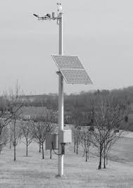
Weather sensor sites represent a collection of roadside weather devices. These devices comprise Ohio’s Road Weather Information System (RWIS). RWIS provides weather and pavement conditions from over 175 stations around the state along ODOT-maintained roadways. RWIS is the critical tool for proactive monitoring of weather conditions around the state and the information provided by RWIS is essential to making numerous management decisions.
RWIS observations are collected every five minutes to provide real time road and weather conditions information to ODOT personnel and the general public. Among the data collected is air temperature, dew point, wind speed and direction, precipitation type and intensity, visibility, road surface temperature, subsurface temperature, and road surface condition. This information is primarily crucial to snow and ice removal efforts but also continues to become more crucial to traffic management strategies
Resource accepts all default Filters.
Weather sensor sites resource also has special Filters for displaying sites with hazards.
Resource data is returned as an API Result model for valid requests or an Error Result model for failed requests. For an example of how to call this resource, see Swagger details.Weather Sensor Site Model
Weather sensor site represents an ODOT monitored weather sensor site with road and atmospheric sensors
- Links ( Array[Link] ) Links related to the current item
- Id ( String ) Unique Identifier
- Latitude ( Double ) The angular distance of a place north or south of the earth's equator
- Longitude ( Double ) The angular distance of a place east or west of the meridian at Greenwich, England
- Location ( String ) Weather sensor site road or intersection
- Description ( String ) Weather sensor site description message
- Severe ( Boolean , optional ) Indicates if severe weather detected
- Condition ( String , optional ) Condition if severe weather detected
- AverageAirTemperature ( String ) Average of all atmospheric sensor temperatures in fahrenheit
- AtmosphericSensors ( Array[AtmosphericSensor] ) List of atmospheric sensors
- SurfaceSensors ( Array[SurfaceSensor] ) List of surface sensors
Link Model
Links capture data related to the current model they live on. The type of link is dependent on the rel property.
- Href ( String ) Url to a page or endpoint
- Rel ( String ) Identifier for the href url. [self] = link to the current item, [documentation] = link to related documentation, [redirect] = link to redirect page
- Method ( String , optional ) Method type of the link. If not displayed then GET is assumed.
Atmospheric Sensor Model
Atmospheric represents data from an ODOT monitored weather atmospheric sensor
- AirTemperature ( Decimal ) Air temperature in fahrenheit
- DewpointTemperature ( Decimal ) Dewpoint temperature in fahrenheit
- Humidity ( Decimal ) Relative humidity percentage
- AverageWindSpeed ( Decimal ) Average wind speed in miles per hour
- MaximumWindSpeed ( Decimal ) Maximum wind speed in miles per hour
- WindDirection ( String ) Wind direction or wind avg direction
- Pressure ( Decimal ) Wind pressure
- Precipitation ( String ) Precipitation type if any
- PrecipitationRate ( Decimal ) Precipitation rate
- PrecipitationAccumulation ( Decimal ) Precipitation accumulation
- Precipitationintensity ( String ) Precipitation intensity
- Visibility ( Decimal ) Senor visibility in miles
- LastUpdate ( DateTime ) Last senor updated date
Surface Sensor Model
Surface Sensor represents data from an ODOT monitored weather surface sensor
- Name ( String ) Name for the sensor
- Status ( String ) Status of the sensor
- SurfaceTemperature ( Decimal ) Surface temperature in fahrenheit
- SubSurfaceTemperature ( Decimal ) Sub-surface temperature in fahrenheit
- LastUpdate ( DateTime ) Last senor updated date